 |
||||||
|
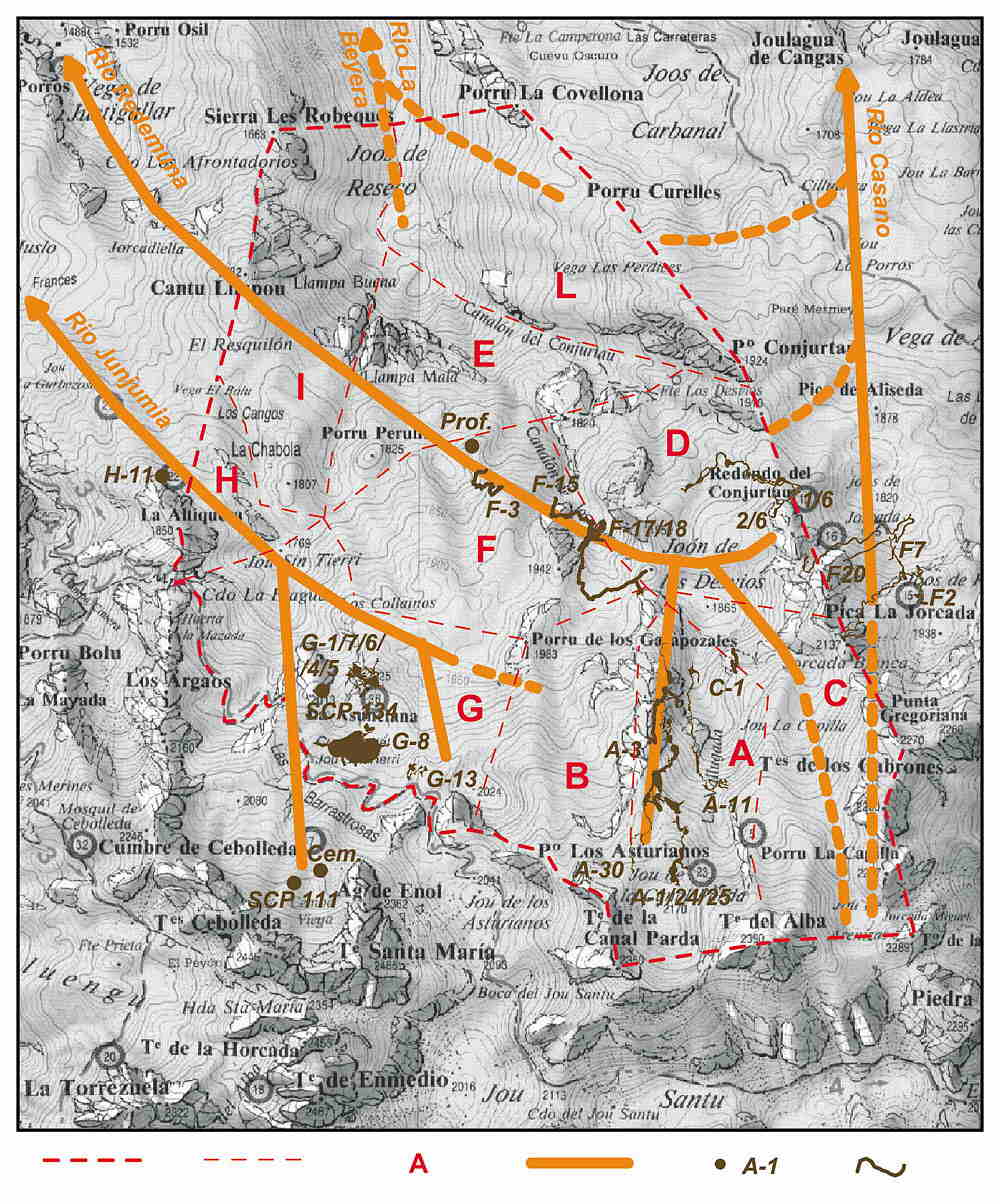
The observations made allowed us to elaborate the concept of the drainage
system in this part of the massif and, consequently, to plan further exploration.
The practically whole area seems to be drained by the Río Dobra, an affluent
of the Río Sella. The drainage occurs three, essentially parallel, NW-trending,
systems. These are the systems related with the Río Junjumia, Río Redemuna
and Río La Beyera, which communicate with the Río Dobra through the Río
Palebarda. The courses of these systems are nearly identical. They begin
in caves which have the maximum vertical and horizontal extents, in their
respective areas, above the level of sumps. Water reaching the sump level
flows NW towards the respective rivers, collecting water from the encountered
cave systems, which are vertically developed before reaching the sump
level. The known caves near the resurgences are active water conduits.
When emergent, the streams maintain their flow direction, until their
waters reach the Río Dobra, which flows to NW and takes the water out
of the massif.
According to this concept, the most important and the longest seems to
be the system connected with the Río Redemuna, more than 5 km long. It
drains the NE and central parts of the area allotted to exploration. The
erosion base for this system lies at altitude 1250-1300 m, while its highest
points reach 2385 m, thus giving a maximum altitude range of 10001100
m. The system extends from beneath Joon de los Desvios towards the north-west
to the Río Redemuna. In its initial course it is supplied, among others,
by the already known cave systems which attain the sump level beneath
Joon de los Desvios. These include:
- on the east, from the slopes of the Redondo del Conjuarto - Sistema
Conjuarto (1/6, 2/6);
- on the south, from the slopes of the Torre de la Canal Parda and the
Torre de los Traviesos - Sistema del Jou de la Canal Parda (A-30/A-25/A-24/A-1)
and Pozu del Porru la Capilla (A-11).
On its way down it collects waters, among others, from Sistema del Canalon
de los Desvios (F-18/F-17/F-15) and before emerging on the surface its
waters flow through (beneath, along) Cueva del Frieru (K-1) and Cueva
del Viento. Other greater caves of this system include Pozu del Porru
de los Garapozales (A-3), Sima de los Desvios (F-3) and Sima Profunda.
The western and southern boundary of this system seem to be the line going
through the Redondo del Conjuarto, Torre de los Traviesos and Torre de
la Canal Parda. It is difficult to ascertain if the this line turns at
the Tiro de la Llera.
Somewhat shorter, no more than 4 km long, is the system connected with
the Río Junjumia. It is relatively little known. Many caves in this area
have been not explored to
the sump level. The system drains the SW part of the area allotted for
exploration. The erosional base lies at altitude 1350-1400 m, while the
highest point may reach 2100 m a.s.l., so the maximum vertical range is
about 700 m. The system runs from somewhere beneath Jou Sin Tierri towards
the NW to the Río Junjumia. In its uppermost course it is supplied, among
others, by the already known cave system Sistema Cembavieja (zone of SCP
Valencia). Other large caves in this area include, besides those situated
in the SCP zone, cave G-13, Red de los Barrastrosas (G-7/G-4/G-5/G-1/G-6),
cave SCP ![]()
|
The deepest caves:
|
|||
| A-30, A-1/24/25 Sistema del Jou de la Canal Parda (-903 m, 4.401 m) |
A-11 Pozu del Porru la Capilla (-863 m, 1.593 m) |
SCP 111, Cem. Sistema Cembavieja (-810 m, ?) |
Sistema Conjurtao (-655 m, 2.435 m) |
| F2, F7 Sistema Jorcada Blanca (-594 m, ?) |
F20 Pozo del Redondo (-582 m, ?) |
F-17/18, F-15 Sistema del Canalon de los Desvios (-542 m, 2.118 m) |
A-3 |
| G-13 bez nazwy (-429 m, 623 m) |
H-11 Sima de la Porra la Altiquera (-418 m, ?) |
F-3 Sima de los Desvios (-323 m, 702 m) 2/6, 1/6 |
G-1/7/6/4/5 |
| SCP 134 bez nazwy (-240 m, ?) |
Prof. Sima Profunda (-204 m, ?) |
Based on:
Miguel Angel Adrados, El Cornion, Mapa Excursionista, 1 : 25 000 SPELEOCLUB WROCŁAW - Marek Jędrzejczak |
|